
Sidney topographic map
Interactive map
Click on the map to display elevation.
About this map
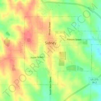
Name: Sidney topographic map, elevation, terrain.
Location: Sidney, Fremont County, Iowa, United States (40.73616 -95.65612 40.75440 -95.62742)
Average elevation: 339 m
Minimum elevation: 304 m
Maximum elevation: 368 m
Other topographic maps
Click on a map to view its topography, its elevation and its terrain.
Farragut
United States > Iowa > Fremont County
Farragut, Fremont County, Iowa, 51639, United States
Average elevation: 292 m
Hamburg
United States > Iowa > Fremont County > Hamburg
Hamburg, Fremont County, Iowa, United States
Average elevation: 285 m
Riverton
United States > Iowa > Fremont County
Riverton, Fremont County, Iowa, United States
Average elevation: 292 m