
Thank you for supporting this site ❤️
Make a donation
Make a donation
Göllü Dağ topographic map
Click on the map to display elevation.
Thank you for supporting this site ❤️
Make a donation
Make a donation
About this map
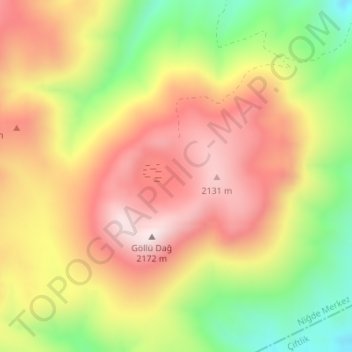
Name: Göllü Dağ topographic map, elevation, terrain.
Location: Göllü Dağ, Niğde, Central Anatolia Region, Turkey (38.25461 34.54455 38.25471 34.54465)
Average elevation: 1,918 m
Minimum elevation: 1,591 m
Maximum elevation: 2,167 m
Thank you for supporting this site ❤️
Make a donation
Make a donation
Other topographic maps
Click on a map to view its topography, its elevation and its terrain.