
Frankenberg/Sachsen topographic map
Interactive map
Click on the map to display elevation.
About this map
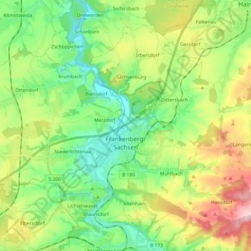
Name: Frankenberg/Sachsen topographic map, elevation, terrain.
Location: Frankenberg/Sachsen, Mittelsachsen, Saksen, 09669, Duitsland (50.87379 12.98835 50.96359 13.16508)
Average elevation: 326 m
Minimum elevation: 235 m
Maximum elevation: 496 m
Other topographic maps
Click on a map to view its topography, its elevation and its terrain.
Freiberg
Duitsland > Saksen > Mittelsachsen
Freiberg, Mittelsachsen, Saksen, 09599, Duitsland
Average elevation: 405 m
Falkenberg
Duitsland > Saksen > Mittelsachsen > Striegistal
Falkenberg, Striegistal, Mittelsachsen, Saksen, 04741, Duitsland
Average elevation: 295 m
Holzhau
Duitsland > Saksen > Mittelsachsen > Holzhau
Holzhau, Rechenberg-Bienenmühle, Mittelsachsen, Saksen, Duitsland
Average elevation: 725 m