
Montgomery County topographic map
Interactive map
Click on the map to display elevation.
About this map
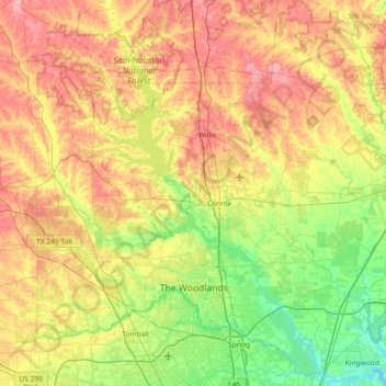
Name: Montgomery County topographic map, elevation, terrain.
Location: Montgomery County, Texas, Estados Unidos da América (30.02618 -95.83016 30.63042 -95.09665)
Average elevation: 69 m
Minimum elevation: 13 m
Maximum elevation: 147 m
Other topographic maps
Click on a map to view its topography, its elevation and its terrain.
The Woodlands
Estados Unidos da América > Texas > Montgomery County
The Woodlands, Montgomery County, Texas, Estados Unidos da América
Average elevation: 47 m