
Birmingham topographic map
Interactive map
Click on the map to display elevation.
About this map
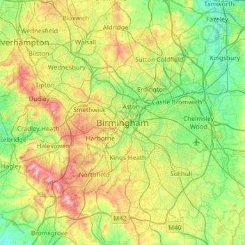
Name: Birmingham topographic map, elevation, terrain.
Average elevation: 130 m
Minimum elevation: 49 m
Maximum elevation: 307 m
Birmingham is a snowy city relative to other large UK conurbations, due to its inland location and comparatively high elevation. Between 1961 and 1990 Birmingham Airport averaged 13.0 days of snow lying annually, compared to 5.33 at London Heathrow. Snow showers often pass through the city via the Cheshire gap on north westerly airstreams, but can also come off the North Sea from north easterly airstreams.
Other topographic maps
Click on a map to view its topography, its elevation and its terrain.
Sparkbrook
United Kingdom > England > Birmingham
Sparkbrook, Birmingham, West Midlands Combined Authority, England, B11 1AG, United Kingdom
Average elevation: 124 m
Attwood Green
United Kingdom > England > Birmingham
Attwood Green, Birmingham, West Midlands Combined Authority, England, B15 2AR, United Kingdom
Average elevation: 131 m
Metchley
United Kingdom > England > Birmingham
Metchley, Birmingham, West Midlands Combined Authority, England, B15 2WB, United Kingdom
Average elevation: 150 m
Balsall Heath
United Kingdom > England > Birmingham
Balsall Heath, Birmingham, West Midlands Combined Authority, England, B12 8SY, United Kingdom
Average elevation: 129 m
Aston
United Kingdom > England > Birmingham
Aston, Birmingham, West Midlands Combined Authority, England, B6 5PL, United Kingdom
Average elevation: 120 m
Park Central
United Kingdom > England > Birmingham
Park Central, Birmingham, West Midlands Combined Authority, England, B15 2GE, United Kingdom
Average elevation: 133 m
Brookvale Village
United Kingdom > England > Birmingham > Brookvale Village
Brookvale Village, Birmingham, West Midlands Combined Authority, England, B23 7YD, United Kingdom
Average elevation: 111 m
Moor End Green
United Kingdom > England > Birmingham > Moor End Green
Moor End Green, Birmingham, West Midlands Combined Authority, West Midlands, England, B24 9DG, United Kingdom
Average elevation: 108 m
Sutton Coldfield
United Kingdom > England > Birmingham
Sutton Coldfield, Birmingham, West Midlands Combined Authority, England, United Kingdom
Average elevation: 124 m