
Bang topographic map
Interactive map
Click on the map to display elevation.
About this map
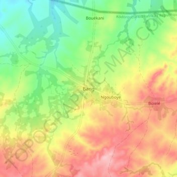
Name: Bang topographic map, elevation, terrain.
Location: Bang, Ouham-Pendé, Central African Republic (7.43639 15.50146 7.51639 15.58146)
Average elevation: 607 m
Minimum elevation: 533 m
Maximum elevation: 687 m
Other topographic maps
Click on a map to view its topography, its elevation and its terrain.
Sah
Central African Republic > Ouham-Pendé
Sah, Ouham-Pendé, Central African Republic
Average elevation: 1,226 m
Kokol
Central African Republic > Ouham-Pendé
Kokol, Ouham-Pendé, Central African Republic
Average elevation: 673 m
De Gaulle
Central African Republic > Ouham-Pendé > De Gaulle
De Gaulle, Ouham-Pendé, Central African Republic
Average elevation: 1,155 m
Bokaya
Central African Republic > Ouham-Pendé > Bokaya
Bokaya, Ouham-Pendé, Central African Republic
Average elevation: 899 m
Bocaranga
Central African Republic > Ouham-Pendé > Bocaranga
Bocaranga, Ouham-Pendé, Central African Republic
Average elevation: 1,026 m