
Daliao topographic map
Interactive map
Click on the map to display elevation.
About this map
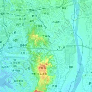
Name: Daliao topographic map, elevation, terrain.
Location: Daliao, Kaohsiung, 831, ROC (22.53249 120.36842 22.65165 120.44709)
Average elevation: 15 m
Minimum elevation: -8 m
Maximum elevation: 122 m
Other topographic maps
Click on a map to view its topography, its elevation and its terrain.
Chengcing Lake
ROC > Kaohsiung > Buzhanyuan
Chengcing Lake, 九曲橋, Sancongzhu, 鳥松里, Buzhanyuan, Niaosong, Kaohsiung, 833, ROC
Average elevation: 21 m