
Wyszków topographic map
Interactive map
Click on the map to display elevation.
About this map
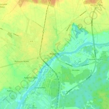
Name: Wyszków topographic map, elevation, terrain.
Average elevation: 94 m
Minimum elevation: 78 m
Maximum elevation: 115 m
Other topographic maps
Click on a map to view its topography, its elevation and its terrain.
Narew
Poland > Masovian Voivodeship > Wyszków County > Stary Lubiel
Narew, Stary Lubiel, gmina Rząśnik, Wyszków County, Masovian Voivodeship, 07-207, Poland
Average elevation: 87 m
Zamość
Poland > Masovian Voivodeship > Wyszków County
Zamość, gmina Długosiodło, Wyszków County, Masovian Voivodeship, 07-211, Poland
Average elevation: 105 m