
Kê Gà topographic map
Interactive map
Click on the map to display elevation.
About this map
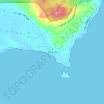
Name: Kê Gà topographic map, elevation, terrain.
Location: Kê Gà, Hàm Thuận Nam District, Bình Thuận Province, Vietnam (10.68486 107.96706 10.72486 108.00706)
Average elevation: 14 m
Minimum elevation: -1 m
Maximum elevation: 124 m
Other topographic maps
Click on a map to view its topography, its elevation and its terrain.
Xã Mương Mán
Vietnam > Binh Thuan province > Hàm Thuận Nam District
Xã Mương Mán, Hàm Thuận Nam District, Bình Thuận Province, Vietnam
Average elevation: 32 m
Thuận Nam
Vietnam > Binh Thuan province > Hàm Thuận Nam District
Thuận Nam, Hàm Thuận Nam District, Bình Thuận Province, Vietnam
Average elevation: 82 m
KDL MuiKeGa-BinhThuan
Vietnam > Binh Thuan province > Hàm Thuận Nam District > Văn Kê
KDL MuiKeGa-BinhThuan, Lạc Long Quân, Văn Kê, Hàm Thuận Nam District, Binh Thuan province, Vietnam
Average elevation: 4 m