
Santa Magdalena topographic map
Interactive map
Click on the map to display elevation.
About this map
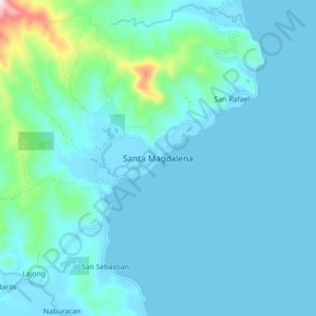
Name: Santa Magdalena topographic map, elevation, terrain.
Location: Santa Magdalena, Sorsogon, Bicol Region, 4709, 菲律宾 / 菲律賓 (12.60633 124.06791 12.68633 124.14791)
Average elevation: 55 m
Minimum elevation: -1 m
Maximum elevation: 504 m
Other topographic maps
Click on a map to view its topography, its elevation and its terrain.