
Ноокат topographic map
Interactive map
Click on the map to display elevation.
About this map
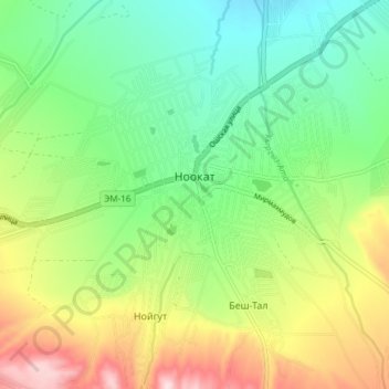
Name: Ноокат topographic map, elevation, terrain.
Location: Ноокат, Ноокатский район, Ошская область, Киргизия (40.23448 72.58889 40.29161 72.65041)
Average elevation: 1,339 m
Minimum elevation: 1,218 m
Maximum elevation: 1,551 m
Ноокат расположен на высоте 1302 м над уровнем моря.
Other topographic maps
Click on a map to view its topography, its elevation and its terrain.
Сары-Могол
Киргизия > Ошская область > Ноокатский район > Сары-Могол
Сары-Могол, Ноокатский район, Ошская область, Киргизия
Average elevation: 3,344 m