
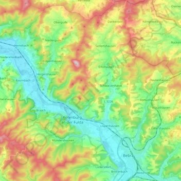
Rotenburg an der Fulda topographic map
Interactive map
Click on the map to display elevation.
About this map
Name: Rotenburg an der Fulda topographic map, elevation, terrain.
Average elevation: 310 m
Minimum elevation: 177 m
Maximum elevation: 540 m
Other topographic maps
Click on a map to view its topography, its elevation and its terrain.
Kirchheim
Duitsland > Hessen > Landkreis Hersfeld-Rotenburg
Kirchheim, Landkreis Hersfeld-Rotenburg, Hessen, 36275, Duitsland
Average elevation: 357 m
Bad Hersfeld
Duitsland > Hessen > Landkreis Hersfeld-Rotenburg
Bad Hersfeld, Landkreis Hersfeld-Rotenburg, Hessen, 36251, Duitsland
Average elevation: 281 m