
Thank you for supporting this site ❤️
Make a donation
Make a donation
Solto Collina topographic map
Click on the map to display elevation.
Thank you for supporting this site ❤️
Make a donation
Make a donation
About this map
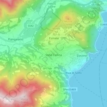
Name: Solto Collina topographic map, elevation, terrain.
Location: Solto Collina, Bergamo, Lombardy, 24060, Italy (45.76074 9.99357 45.80398 10.06507)
Average elevation: 479 m
Minimum elevation: 177 m
Maximum elevation: 1,226 m
Thank you for supporting this site ❤️
Make a donation
Make a donation
Other topographic maps
Click on a map to view its topography, its elevation and its terrain.
Thank you for supporting this site ❤️
Make a donation
Make a donation
Thank you for supporting this site ❤️
Make a donation
Make a donation