
Wykagyl Park topographic map
Interactive map
Click on the map to display elevation.
About this map
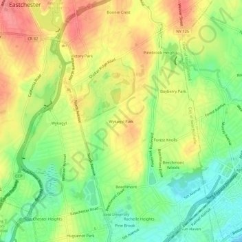
Name: Wykagyl Park topographic map, elevation, terrain.
Average elevation: 41 m
Minimum elevation: 2 m
Maximum elevation: 80 m
Other topographic maps
Click on a map to view its topography, its elevation and its terrain.
Isle of San Souci
United States > New York > Westchester County > City of New Rochelle
Isle of San Souci, City of New Rochelle, Westchester County, New York, 10805, United States
Average elevation: 7 m
Sun Haven
United States > New York > Westchester County > City of New Rochelle
Sun Haven, City of New Rochelle, Westchester County, New York, 10538, United States
Average elevation: 20 m