
Thank you for supporting this site ❤️
Make a donation
Make a donation
Aru topographic map
Click on the map to display elevation.
Thank you for supporting this site ❤️
Make a donation
Make a donation
About this map
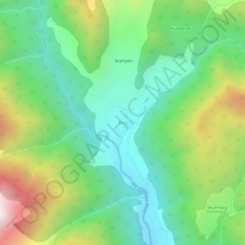
Name: Aru topographic map, elevation, terrain.
Location: Aru, Pahalgam, Anantnag District, Jammu and Kashmir, India (34.07030 75.24244 34.11030 75.28244)
Average elevation: 2,764 m
Minimum elevation: 2,305 m
Maximum elevation: 3,691 m
Thank you for supporting this site ❤️
Make a donation
Make a donation