
Thank you for supporting this site ❤️
Make a donation
Make a donation
Tomislavgrad topographic map
Click on the map to display elevation.
Thank you for supporting this site ❤️
Make a donation
Make a donation
About this map
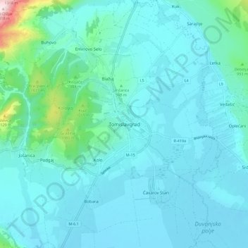
Name: Tomislavgrad topographic map, elevation, terrain.
Average elevation: 913 m
Minimum elevation: 858 m
Maximum elevation: 1,334 m
Thank you for supporting this site ❤️
Make a donation
Make a donation
Other topographic maps
Click on a map to view its topography, its elevation and its terrain.
Mostar
Bosnia and Herzegovina > Federation of Bosnia and Herzegovina > City of Mostar
Average elevation: 221 m