
New Ipswich topographic map
Interactive map
Click on the map to display elevation.
New Ipswich
According to the United States Census Bureau, the town has a total area of 33.1 square miles (85.6 km2), of which 32.7 square miles (84.8 km2) are land and 0.3 square miles (0.8 km2) are water, comprising 0.97% of the town. The eastern and central parts of New Ipswich are drained by the Souhegan River, a northeastward-flowing tributary of the Merrimack River. New Ipswich Mountain, part of the Wapack Range, is the highest point in the town, with an elevation of 1,881 feet (573 m) above sea level. On the west side of the Wapack Range, the northwestern corner of town is drained by the Gridley River, a northwestward-flowing tributary of the Contoocook River, which continues north to the Merrimack. The southwestern part of town, including Mountain Pond, Island Pond, and Binney Pond, comprise headwaters of the Millers River, which flows southwest into Massachusetts, part of the Connecticut River watershed.
About this map
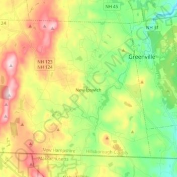
Name: New Ipswich topographic map, elevation, terrain.
Average elevation: 339 m
Minimum elevation: 180 m
Maximum elevation: 566 m
Other topographic maps
Click on a map to view its topography, its elevation and its terrain.
South Uncanoonuc Mountain
United States > New Hampshire > Hillsborough County > Goffstown
Average elevation: 243 m
Souhegan River
United States > New Hampshire > Hillsborough County > Milford > East Milford
Average elevation: 84 m
Piscataquog River
United States > New Hampshire > Hillsborough County > Manchester
Average elevation: 59 m
Souhegan River Watershed Dam Number 35
United States > New Hampshire > Hillsborough County > New Ipswich > Smithville
Average elevation: 349 m
West Peterborough
United States > New Hampshire > Hillsborough County > Peterborough
Average elevation: 299 m
Hillsboro Lower Village
United States > New Hampshire > Hillsborough County > Hillsborough
Average elevation: 242 m
Campbell Mountain
United States > New Hampshire > Hillsborough County > Hillsborough
Average elevation: 338 m
Massachusetts Drive Park
United States > New Hampshire > Hillsborough County > Nashua
Average elevation: 48 m
Souhegan River
United States > New Hampshire > Hillsborough County > Milford > East Milford
Average elevation: 84 m
North Brookline
United States > New Hampshire > Hillsborough County > Brookline > North Brookline
Average elevation: 124 m
North Village
United States > New Hampshire > Hillsborough County > Peterborough
Average elevation: 251 m
Nakuru Lake
United States > New Hampshire > Hillsborough County > Hudson > Hudson Center
Average elevation: 80 m
South Weare
United States > New Hampshire > Hillsborough County > Weare > South Weare
Average elevation: 210 m