
Make a donation
Pennewitz topographic map
Click on the map to display elevation.
Make a donation
Pennewitz
Ortsteile: Bücheloh | Frauenwald mit Allzunah | Gehren | Gräfinau-Angstedt mit Annawerk und Lehmannsbrück | Heyda | Ilmenau | Jesuborn | Langewiesen | Manebach | Möhrenbach | Oehrenstock | Oberpörlitz | Pennewitz mit Sorge | Roda | Stützerbach | Unterpörlitz | Wümbach Weitere Stadtteile: Campus | Eichicht | Gabelbach | Grenzhammer | Kurviertel | Neuhaus | Pörlitzer Höhe | Stollen
Make a donation
About this map
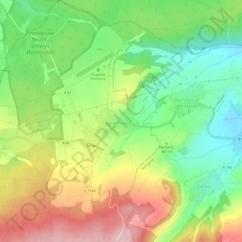
Name: Pennewitz topographic map, elevation, terrain.
Location: Pennewitz, Ilmenau, Ilm-Kreis, Thüringen, 98708, Deutschland (50.64256 11.02951 50.67956 11.06661)
Average elevation: 471 m
Minimum elevation: 372 m
Maximum elevation: 600 m
Make a donation
Other topographic maps
Click on a map to view its topography, its elevation and its terrain.
Bücheloh
Deutschland > Thüringen > Ilm-Kreis > Ilmenau
Bücheloh liegt im Tal des Humbachs, einem Nebenfluss der Ilm auf einer Höhe von etwa 470 Metern. Der Ort ist ein Straßendorf, dass sich ca. zwei Kilometer an der Landesstraße 3087 hinzieht.
Average elevation: 466 m
Oehrenstock
Deutschland > Thüringen > Ilm-Kreis > Ilmenau
Oehrenstock liegt in etwa 575 Metern Höhe im Thüringer Wald. Der Ort wird von der Oehre, einem Nebenfluss der Schorte durchflossen. Südlich von Oehrenstock liegt der 774 Meter hohe Kienberg. In der Umgebung von Oehrenstock liegen zahlreiche Stollen, die von früheren Bergbau auf Mangan und Flussspat zeugen.
Average elevation: 572 m
Make a donation
Heyda
Deutschland > Thüringen > Ilm-Kreis > Ilmenau
Heyda liegt etwa sechs Kilometer nördlich von Ilmenau. Die Talsperre Heyda, östlich des Ortes, wird durch das Flüsschen Wipfra gespeist, das seinen Verlauf jedoch außerhalb des Dorfgebietes hat. Ein weiterer Zulauf zum See ist ein kleiner Bach, der sich durch Heyda schlängelt. Die Landschaft in der…
Average elevation: 471 m
Gräfinau-Angstedt
Deutschland > Thüringen > Ilm-Kreis > Ilmenau
Ortsteile: Bücheloh | Frauenwald mit Allzunah | Gehren | Gräfinau-Angstedt mit Annawerk und Lehmannsbrück | Heyda | Ilmenau | Jesuborn | Langewiesen | Manebach | Möhrenbach | Oehrenstock | Oberpörlitz | Pennewitz mit Sorge | Roda | Stützerbach | Unterpörlitz | Wümbach Weitere Stadtteile: Campus |…
Average elevation: 450 m
Kickelhahn
Deutschland > Thüringen > Ilm-Kreis > Ilmenau
Der Kickelhahn ist mit 861 Metern die höchste Erhebung im Ilm-Kreis. Historisch war er auch der höchste Berg von Sachsen-Weimar-Eisenach. Sein Massiv wird begrenzt durch das Tal der Ilm im Westen und Norden, des Gabelbachs im Osten sowie des Langebachs im Süden. Damit liegt der Berg vollständig im…
Average elevation: 687 m
Make a donation