
Thank you for supporting this site ❤️
Make a donation
Make a donation
Chaupiloma topographic map
Click on the map to display elevation.
Thank you for supporting this site ❤️
Make a donation
Make a donation
About this map
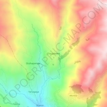
Name: Chaupiloma topographic map, elevation, terrain.
Location: Chaupiloma, Cajay, Huari, Áncash, Perú (-9.22805 -77.18804 -9.18805 -77.14804)
Average elevation: 4,069 m
Minimum elevation: 3,643 m
Maximum elevation: 4,460 m
Thank you for supporting this site ❤️
Make a donation
Make a donation
Other topographic maps
Click on a map to view its topography, its elevation and its terrain.