
Durand topographic map
Interactive map
Click on the map to display elevation.
About this map
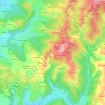
Name: Durand topographic map, elevation, terrain.
Average elevation: 230 m
Minimum elevation: 136 m
Maximum elevation: 349 m
Other topographic maps
Click on a map to view its topography, its elevation and its terrain.
La Queyrille
France > Nouvelle-Aquitaine > Corrèze > Queyssac-les-Vignes
La Queyrille, Queyssac-les-Vignes, Brive-la-Gaillarde, Corrèze, Nouvelle-Aquitaine, France métropolitaine, 19120, France
Average elevation: 228 m
La Barrière
France > Nouvelle-Aquitaine > Corrèze > Queyssac-les-Vignes
La Barrière, Queyssac-les-Vignes, Brive-la-Gaillarde, Corrèze, Nouvelle-Aquitaine, France métropolitaine, 19120, France
Average elevation: 216 m