
Thank you for supporting this site ❤️
Make a donation
Make a donation
Doernel topographic map
Click on the map to display elevation.
Thank you for supporting this site ❤️
Make a donation
Make a donation
About this map
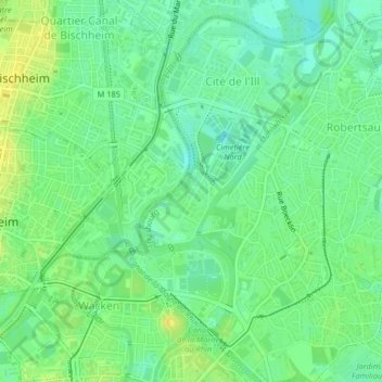
Name: Doernel topographic map, elevation, terrain.
Average elevation: 140 m
Minimum elevation: 130 m
Maximum elevation: 150 m
Thank you for supporting this site ❤️
Make a donation
Make a donation
Other topographic maps
Click on a map to view its topography, its elevation and its terrain.
Thank you for supporting this site ❤️
Make a donation
Make a donation
Bassin aux Pétroles et Bassin Albert Auberger
France > Grand Est > Bas-Rhin > Strasbourg
Average elevation: 138 m
Thank you for supporting this site ❤️
Make a donation
Make a donation
Bassin aux Pétroles et Bassin Albert Auberger
France > Grand Est > Bas-Rhin > Strasbourg
Average elevation: 138 m
Thank you for supporting this site ❤️
Make a donation
Make a donation