
La Palmita topographic map
Interactive map
Click on the map to display elevation.
About this map
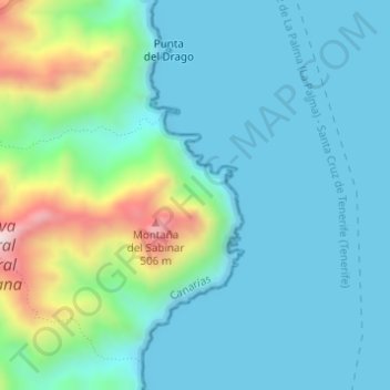
Name: La Palmita topographic map, elevation, terrain.
Location: La Palmita, Santa Cruz de Ténérife, Îles Canaries, Espagne (28.55602 -16.12457 28.55902 -16.12166)
Average elevation: 110 m
Minimum elevation: -1 m
Maximum elevation: 540 m
Other topographic maps
Click on a map to view its topography, its elevation and its terrain.
El Pilón
Espagne > Îles Canaries > Santa Cruz de Ténérife
El Pilón, Santa Cruz de Ténérife, Îles Canaries, 38129, Espagne
Average elevation: 432 m