
Heard Island and McDonald Islands topographic map
Interactive map
Click on the map to display elevation.
Heard Island and McDonald Islands
Heard Island, by far the largest of the group, is a 368-square-kilometre (142 sq mi) mountainous island covered by 41 glaciers (the island is 80% covered with ice) and dominated by the Big Ben massif. It has a maximum elevation of 2,745 metres (9,006 ft) at Mawson Peak, the historically active volcanic summit of Big Ben, to which the average ascent from shore is steeper than that for any island of comparable size or larger; only seven smaller islands are steeper. A July 2000 satellite image from the University of Hawaii's Institute of Geophysics and Planetology (HIGP) Thermal Alert Team showed an active 2-kilometre-long (1.2 mi) and 50- to 90-metre-wide (164–295 ft) lava flow trending south-west from the summit of Big Ben.
About this map
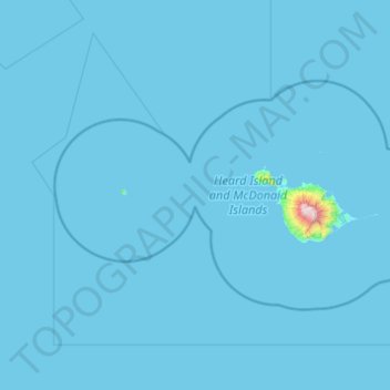
Name: Heard Island and McDonald Islands topographic map, elevation, terrain.
Location: Heard Island and McDonald Islands, Australia (-53.39470 72.24619 -52.70313 74.20453)
Average elevation: 12 m
Minimum elevation: -1 m
Maximum elevation: 2,608 m
Other topographic maps
Click on a map to view its topography, its elevation and its terrain.
Toowoomba
The city occupies the edge of the range and the low ridges behind it. Two valleys run north from the southern boundary, each arising from springs either side of Middle Ridge near Spring Street at an altitude of around 680 m. These waterways, East Creek and West Creek, flow together just north of the CBD to…
Average elevation: 458 m