
Thank you for supporting this site ❤️
Make a donation
Make a donation
New Salem topographic map
Click on the map to display elevation.
Thank you for supporting this site ❤️
Make a donation
Make a donation
About this map
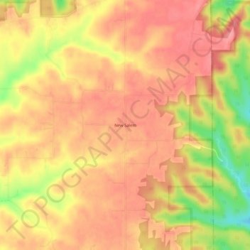
Name: New Salem topographic map, elevation, terrain.
Location: New Salem, Washington County, Indiana, United States (38.60145 -85.92414 38.64145 -85.88414)
Average elevation: 286 m
Minimum elevation: 222 m
Maximum elevation: 315 m
Thank you for supporting this site ❤️
Make a donation
Make a donation
Other topographic maps
Click on a map to view its topography, its elevation and its terrain.