
Thank you for supporting this site ❤️
Make a donation
Make a donation
Long Hill topographic map
Click on the map to display elevation.
Thank you for supporting this site ❤️
Make a donation
Make a donation
About this map
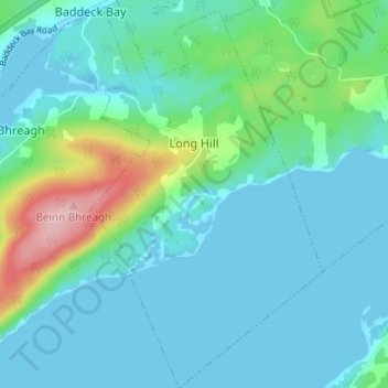
Name: Long Hill topographic map, elevation, terrain.
Average elevation: 32 m
Minimum elevation: -3 m
Maximum elevation: 173 m
Thank you for supporting this site ❤️
Make a donation
Make a donation
Other topographic maps
Click on a map to view its topography, its elevation and its terrain.
South Harbour
Canada > Nova Scotia > Municipality of Victoria County > South Harbour
Average elevation: 22 m
Kidston Island Lighthouse
Canada > Nova Scotia > Municipality of Victoria County > Baddeck
Average elevation: 11 m
Old Fort Point
Canada > Nova Scotia > Municipality of Victoria County > Englishtown
Average elevation: 32 m