
Thank you for supporting this site ❤️
Make a donation
Make a donation
Wallis topographic map
Click on the map to display elevation.
Thank you for supporting this site ❤️
Make a donation
Make a donation
About this map
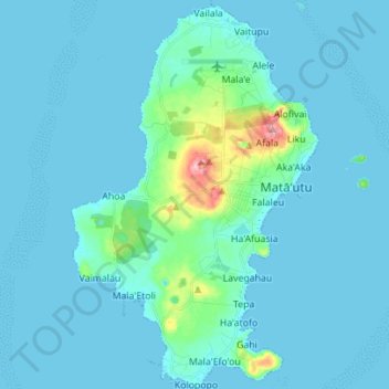
Name: Wallis topographic map, elevation, terrain.
Location: Wallis, Uvea, Wallis and Futuna, 98600, France (-13.35221 -176.25104 -13.21707 -176.16222)
Average elevation: 13 m
Minimum elevation: -1 m
Maximum elevation: 149 m
Thank you for supporting this site ❤️
Make a donation
Make a donation
Other topographic maps
Click on a map to view its topography, its elevation and its terrain.