
Thank you for supporting this site ❤️
Make a donation
Make a donation
Cubagua Island topographic map
Click on the map to display elevation.
Thank you for supporting this site ❤️
Make a donation
Make a donation
Cubagua Island
The island is 9.2 by 3.6 km (5.7 by 2.2 mi) in size, an elliptical shape with the longer axis east-west. Its area is 22.438 km2 (9 sq mi). The coast consists of some beaches as well as cliffs from 5 to 7 metres (16 to 23 ft) high in the south and from 20 to 24 metres (66 to 79 ft) high in the north. The highest elevation of the flat-topped island reaches 32 metres (105 ft).
Thank you for supporting this site ❤️
Make a donation
Make a donation
About this map
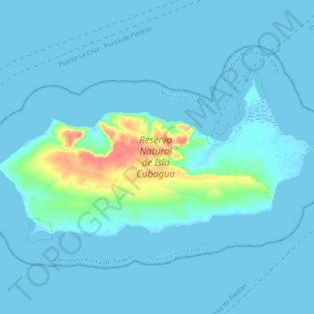
Name: Cubagua Island topographic map, elevation, terrain.
Average elevation: 6 m
Minimum elevation: -2 m
Maximum elevation: 56 m
Thank you for supporting this site ❤️
Make a donation
Make a donation
Other topographic maps
Click on a map to view its topography, its elevation and its terrain.