
Make a donation
Mattighofen topographic map
Click on the map to display elevation.
Make a donation
Mattighofen
Mattighofen liegt auf 454 m Höhe im Innviertel. Die Ausdehnung beträgt von Nord nach Süd 3 km, von West nach Ost 3,3 km. Die Gesamtfläche beträgt 5,2 km². 13,5 % der Fläche sind bewaldet, 50,0 % der Fläche sind landwirtschaftlich genutzt.
Make a donation
About this map
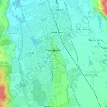
Name: Mattighofen topographic map, elevation, terrain.
Average elevation: 451 m
Minimum elevation: 430 m
Maximum elevation: 533 m
Make a donation
Other topographic maps
Click on a map to view its topography, its elevation and its terrain.
Lohnsberg
Österreich > Oberösterreich > Bezirk Braunau am Inn > Gilgenberg am Weilhart > Lohnsberg
Average elevation: 480 m
Sankt Wolfgang
Österreich > Oberösterreich > Bezirk Braunau am Inn > Munderfing
Average elevation: 643 m
Osternberg
Österreich > Oberösterreich > Bezirk Braunau am Inn > Braunau am Inn
Average elevation: 358 m
Make a donation