
Thank you for supporting this site ❤️
Make a donation
Make a donation
Horton Bay topographic map
Click on the map to display elevation.
Thank you for supporting this site ❤️
Make a donation
Make a donation
About this map
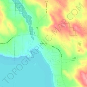
Name: Horton Bay topographic map, elevation, terrain.
Average elevation: 208 m
Minimum elevation: 166 m
Maximum elevation: 275 m
Thank you for supporting this site ❤️
Make a donation
Make a donation
Other topographic maps
Click on a map to view its topography, its elevation and its terrain.
Thank you for supporting this site ❤️
Make a donation
Make a donation
Charlevoix South Pier Light
United States > Michigan > Charlevoix County > Charlevoix
Average elevation: 180 m
Thank you for supporting this site ❤️
Make a donation
Make a donation
Thank you for supporting this site ❤️
Make a donation
Make a donation