
Neudörfl topographic map
Interactive map
Click on the map to display elevation.
About this map
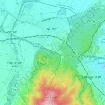
Name: Neudörfl topographic map, elevation, terrain.
Location: Neudörfl, Bezirk Mattersburg, Burgenland, 7201, Österreich (47.76173 16.26858 47.81145 16.31681)
Average elevation: 307 m
Minimum elevation: 240 m
Maximum elevation: 559 m
Vor Christi Geburt war das Gebiet Teil des keltischen Königreiches Noricum und gehörte zur Umgebung der keltischen Höhensiedlung Burg auf dem Schwarzenbacher Burgberg. Unter den Römern lag das heutige Neudörfl dann in der Provinz Pannonia.