
Thank you for supporting this site ❤️
Make a donation
Make a donation
Bleiksveien topographic map
Click on the map to display elevation.
Thank you for supporting this site ❤️
Make a donation
Make a donation
About this map
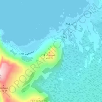
Name: Bleiksveien topographic map, elevation, terrain.
Location: Bleiksveien, Damsgård, Toften, Andøy, Нурланн, Норвегия (69.29364 16.04012 69.29374 16.04022)
Average elevation: 57 m
Minimum elevation: 0 m
Maximum elevation: 438 m
Thank you for supporting this site ❤️
Make a donation
Make a donation
Other topographic maps
Click on a map to view its topography, its elevation and its terrain.
Thank you for supporting this site ❤️
Make a donation
Make a donation