
Natternbach topographic map
Interactive map
Click on the map to display elevation.
About this map
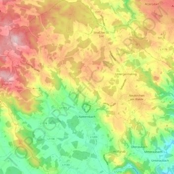
Name: Natternbach topographic map, elevation, terrain.
Average elevation: 513 m
Minimum elevation: 382 m
Maximum elevation: 655 m
Natternbach liegt auf 434 Metern Höhe im Hausruckviertel. Die Ausdehnung beträgt von Nord nach Süd 8,6 Kilometer, von West nach Ost 6,6 Kilometer. Die Gesamtfläche beträgt 30,9 km². 35,6 % der Fläche sind bewaldet, 57,9 % der Fläche sind landwirtschaftlich genutzt.
Other topographic maps
Click on a map to view its topography, its elevation and its terrain.
Gaisbuchen
Österreich > Oberösterreich > Natternbach > Gaisbuchen
Gaisbuchen, Natternbach, Bezirk Grieskirchen, Oberösterreich, 4723, Österreich
Average elevation: 535 m