
Thank you for supporting this site ❤️
Make a donation
Make a donation
Bearfort Mountain topographic map
Click on the map to display elevation.
Thank you for supporting this site ❤️
Make a donation
Make a donation
Bearfort Mountain
At an elevation of 1,331 feet (406 m) the ridge is the site of a 68 feet (21 m) high fire lookout tower built by the New Jersey Forest Fire Service.
Thank you for supporting this site ❤️
Make a donation
Make a donation
About this map
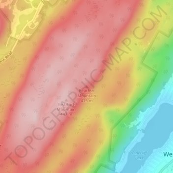
Name: Bearfort Mountain topographic map, elevation, terrain.
Average elevation: 354 m
Minimum elevation: 192 m
Maximum elevation: 446 m
Thank you for supporting this site ❤️
Make a donation
Make a donation
Other topographic maps
Click on a map to view its topography, its elevation and its terrain.
Abram S. Hewitt State Forest
United States > New Jersey > Passaic County > West Milford
Average elevation: 318 m