
Lower Kilcott topographic map
Click on the map to display elevation.
About this map
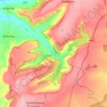
Name: Lower Kilcott topographic map, elevation, terrain.
Average elevation: 153 m
Minimum elevation: 58 m
Maximum elevation: 203 m
Other topographic maps
Click on a map to view its topography, its elevation and its terrain.
Jubilee Playing Field & Athletics Track
United Kingdom > England > Gloucestershire > Stroud > Cam > Draycott
Average elevation: 45 m
Rodborough Common
United Kingdom > England > Gloucestershire > Stroud > Lightpill
Average elevation: 114 m
Gloucester and Sharpness Canal
United Kingdom > England > Gloucestershire > Stroud
Average elevation: 34 m
River Frome
United Kingdom > England > Gloucestershire > Stroud > Chalford > Chalford Hill
Average elevation: 163 m
Miserden Estate
United Kingdom > England > Gloucestershire > Stroud > Miserden
Average elevation: 218 m
Alderley
United Kingdom > England > Gloucestershire > Stroud
In A Topographical Dictionary of England by Samuel Lewis published in 1831, Alderley is described thus.
Average elevation: 95 m