
Aheimberg topographic map
Interactive map
Click on the map to display elevation.
About this map
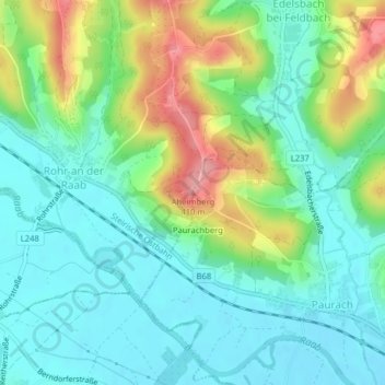
Name: Aheimberg topographic map, elevation, terrain.
Average elevation: 322 m
Minimum elevation: 286 m
Maximum elevation: 405 m
Other topographic maps
Click on a map to view its topography, its elevation and its terrain.
Paurachberg
Österreich > Steiermark > Feldbach > Paurach > Paurachberg
Paurachberg, Paurach, Feldbach, Bezirk Südoststeiermark, Steiermark, 8330, Österreich
Average elevation: 325 m
Schloss Hainfeld
Österreich > Steiermark > Feldbach
Schloss Hainfeld, Schloßweg, Feldbach, Südoststeiermark, Steiermark, 8330, Österreich
Average elevation: 295 m