
Vaugelas topographic map
Interactive map
Click on the map to display elevation.
About this map
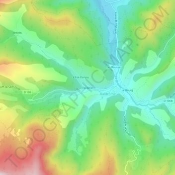
Name: Vaugelas topographic map, elevation, terrain.
Average elevation: 964 m
Minimum elevation: 743 m
Maximum elevation: 1,361 m
Other topographic maps
Click on a map to view its topography, its elevation and its terrain.
Les Bascous
France > Auvergne-Rhône-Alpes > Drôme > Valdrôme
Les Bascous, Valdrôme, Die, Drôme, Auvergne-Rhône-Alpes, France métropolitaine, 26310, France
Average elevation: 1,162 m
Le Bourg
France > Auvergne-Rhône-Alpes > Drôme > Valdrôme
Le Bourg, Valdrôme, Die, Drôme, Auvergne-Rhône-Alpes, France métropolitaine, 26310, France
Average elevation: 946 m