
Make a donation
Bingawan topographic map
Click on the map to display elevation.
Make a donation
Bingawan
Bingawan is relatively dry from November to April and wet during the rest of the year. The maximum rain periods are not very heavy with a short dry season lasting from one to three months. The climate is influenced by the southeast monsoons, one of the principal air streams affecting the country. Local topography affects its exposure to prevailing winds.
Make a donation
About this map
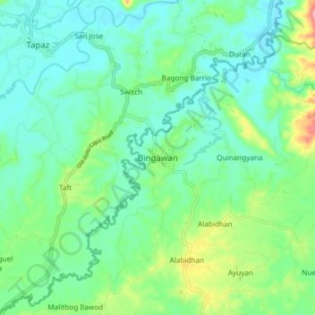
Name: Bingawan topographic map, elevation, terrain.
Location: Bingawan, Iloilo, Western Visayas, 5041, Philippines (11.19326 122.52696 11.27326 122.60696)
Average elevation: 64 m
Minimum elevation: 23 m
Maximum elevation: 187 m
Make a donation
Other topographic maps
Click on a map to view its topography, its elevation and its terrain.
Panay
Panay island is the sixth largest island in the Philippines by area, with a total land area of 12,011 km2 (4,637 sq mi). Mount Madja-as is the highest point in Panay with an elevation of 2,117 metres (6,946 ft) above sea level, located in town of Culasi in the northern province of Antique. Central Panay…
Average elevation: 117 m
Make a donation
Make a donation
Panay
Panay island is the sixth largest island in the Philippines by area, with a total land area of 12,011 km2 (4,637 sq mi). Mount Madja-as is the highest point in Panay with an elevation of 2,117 metres (6,946 ft) above sea level, located in town of Culasi in the northern province of Antique. Central Panay…
Average elevation: 117 m
Make a donation
Guimbal
Guimbal, a coastal municipality, is located at the south-western part of Iloilo province. It is situated between the coordinates of 1250 57’ longitude, and 100 39’ latitude. It is 29 kilometres (18 mi) from Iloilo City, and has a total land area of 4,461 hectares (11,020 acres). It is only six feet above…
Average elevation: 27 m
Make a donation
Make a donation
Make a donation
Make a donation
Make a donation
Guimbal
Guimbal, a coastal municipality, is located at the south-western part of Iloilo province. It is situated between the coordinates of 1250 57’ longitude, and 100 39’ latitude. It is 29 kilometres (18 mi) from Iloilo City, and has a total land area of 4,461 hectares (11,020 acres). It is only six feet above…
Average elevation: 27 m
Make a donation
Make a donation
Panay
Panay island is the sixth largest island in the Philippines by area, with a total land area of 12,011 km2 (4,637 sq mi). Mount Madja-as is the highest point in Panay with an elevation of 2,117 metres (6,946 ft) above sea level, located in town of Culasi in the northern province of Antique. Central Panay…
Average elevation: 117 m
Make a donation
Guimbal
Guimbal, a coastal municipality, is located at the south-western part of Iloilo province. It is situated between the coordinates of 1250 57’ longitude, and 100 39’ latitude. It is 29 kilometres (18 mi) from Iloilo City, and has a total land area of 4,461 hectares (11,020 acres). It is only six feet above…
Average elevation: 27 m
Panay
Panay island is the sixth largest island in the Philippines by area, with a total land area of 12,011 km2 (4,637 sq mi). Mount Madja-as is the highest point in Panay with an elevation of 2,117 metres (6,946 ft) above sea level, located in town of Culasi in the northern province of Antique. Central Panay…
Average elevation: 117 m
Make a donation
Make a donation