
Make a donation
Fort Lucas topographic map
Click on the map to display elevation.
Make a donation
About this map
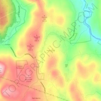
Name: Fort Lucas topographic map, elevation, terrain.
Average elevation: 267 m
Minimum elevation: 105 m
Maximum elevation: 412 m
Make a donation
Other topographic maps
Click on a map to view its topography, its elevation and its terrain.
Make a donation
Make a donation
Erving
United States > Massachusetts > Franklin County
The town is home to a number of topographic features popular among outdoor recreation enthusiasts. Erving State Forest has recreation and seasonal camping facilities. The Millers River is used for fishing and whitewater kayaking. Northfield Mountain hosts cross country ski trails, hiking trails, and rock…
Average elevation: 255 m
Make a donation
Make a donation
Make a donation
Make a donation
Make a donation
Wendell State Forest
United States > Massachusetts > Franklin County > Montague
Average elevation: 263 m
Make a donation
Leverett
United States > Massachusetts > Franklin County
According to the United States Census Bureau, the town has a total area of 23.0 square miles (60 km2), of which 22.9 square miles (59 km2) are land and 0.1-square-mile (0.26 km2) (0.61%) is water. Leverett is located on the edge of the Pioneer Valley and the hills of northwestern Massachusetts, just east of…
Average elevation: 220 m
Make a donation
Make a donation