
Río Cofio topographic map
Interactive map
Click on the map to display elevation.
About this map
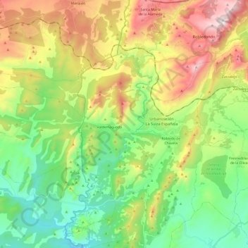
Name: Río Cofio topographic map, elevation, terrain.
Average elevation: 996 m
Minimum elevation: 599 m
Maximum elevation: 1,674 m
Other topographic maps
Click on a map to view its topography, its elevation and its terrain.
El Robledillo
España > Comunidad de Madrid > Robledo de Chavela
El Robledillo, Robledo de Chavela, Sierra Oeste, Comunidad de Madrid, 28210, España
Average elevation: 1,216 m