
Make a donation
Faucett topographic map
Click on the map to display elevation.
Make a donation
About this map
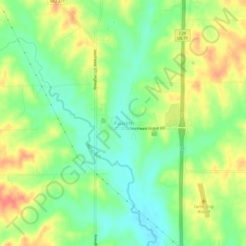
Name: Faucett topographic map, elevation, terrain.
Location: Faucett, Buchanan County, Missouri, 64448, United States (39.58060 -94.82102 39.62060 -94.78102)
Average elevation: 305 m
Minimum elevation: 280 m
Maximum elevation: 335 m
Make a donation
Other topographic maps
Click on a map to view its topography, its elevation and its terrain.
Saint Joseph
United States > Missouri > Buchanan County
Under the Köppen climate classification, St. Joseph has a humid subtropical climate (Cfa) bordering on a humid continental climate (Dfa), although under United States isotherms of 32 °F (0 °C) the station is firmly continental. The monthly weather averages listed below are taken from National Weather…
Average elevation: 277 m
Make a donation