
Thank you for supporting this site ❤️
Make a donation
Make a donation
Delmas, Ouest topographic map
Click on the map to display elevation.
Thank you for supporting this site ❤️
Make a donation
Make a donation
About this map
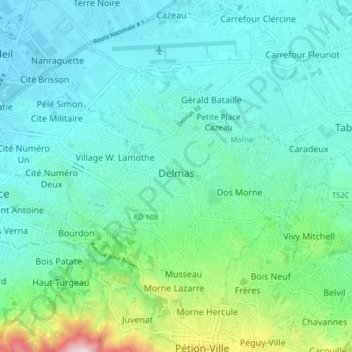
Name: Delmas, Ouest topographic map, elevation, terrain.
Location: Delmas, Ouest, Port-au-Prince Arrondissement, West, Haiti (18.52213 -72.33860 18.58035 -72.25662)
Average elevation: 132 m
Minimum elevation: 5 m
Maximum elevation: 685 m
Thank you for supporting this site ❤️
Make a donation
Make a donation
Other topographic maps
Click on a map to view its topography, its elevation and its terrain.
Thank you for supporting this site ❤️
Make a donation
Make a donation
Thank you for supporting this site ❤️
Make a donation
Make a donation
Port-au-Prince
Haiti > West > Port-au-Prince
By then, the colonial administration was convinced that a capital needed to be chosen, in order to better control the French portion of Hispaniola (Saint-Domingue). For a time, Petit-Goâve and Léogâne vied for this honor, but both were eventually ruled out for various reasons. Neither was centrally located.…
Average elevation: 376 m
Thank you for supporting this site ❤️
Make a donation
Make a donation
Thank you for supporting this site ❤️
Make a donation
Make a donation
Thank you for supporting this site ❤️
Make a donation
Make a donation