
Thank you for supporting this site ❤️
Make a donation
Make a donation
Wonder Lake topographic map
Click on the map to display elevation.
Thank you for supporting this site ❤️
Make a donation
Make a donation
About this map
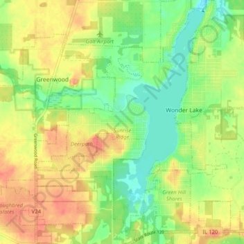
Name: Wonder Lake topographic map, elevation, terrain.
Location: Wonder Lake, McHenry County, Illinois, 60097, United States (42.35366 -88.39387 42.41108 -88.33367)
Average elevation: 262 m
Minimum elevation: 238 m
Maximum elevation: 286 m
Thank you for supporting this site ❤️
Make a donation
Make a donation
Other topographic maps
Click on a map to view its topography, its elevation and its terrain.
Elizabeth Lake Nature Preserve
United States > Illinois > McHenry County > Twin Lakes
Average elevation: 250 m
Thank you for supporting this site ❤️
Make a donation
Make a donation