
Make a donation
Baio Dora topographic map
Click on the map to display elevation.
Make a donation
About this map
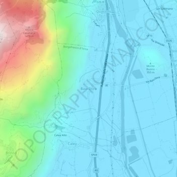
Name: Baio Dora topographic map, elevation, terrain.
Location: Baio Dora, Borgofranco d'Ivrea, Turin, Piedmont, 10013, Italy (45.48700 7.80825 45.52700 7.84825)
Average elevation: 494 m
Minimum elevation: 241 m
Maximum elevation: 1,605 m
Make a donation
Other topographic maps
Click on a map to view its topography, its elevation and its terrain.
Make a donation
Ivrea
Ivrea is situated at an altitude of approximately 267 meters above sea level, not far from the entrance to the Aosta Valley. It is crossed by the Dora Baltea river, a tributary of the Po, and is located in an area shaped by a large Pleistocene glacier, which over time transported numerous debris that formed a…
Average elevation: 243 m
Make a donation
Sestriere
An elite track and field athletics meeting was held annually in Sestriere from 1988 to 1996, and again in 2004. The advantage of its high altitude in sprinting and jumping events held out hope of world records, with sponsor Ferrari offering a car as a bonus. One record was set, in the men's pole vault by…
Average elevation: 2,120 m
Make a donation
Make a donation
Make a donation
Make a donation
Make a donation
Make a donation