
Thank you for supporting this site ❤️
Make a donation
Make a donation
Carrot Hill topographic map
Click on the map to display elevation.
Thank you for supporting this site ❤️
Make a donation
Make a donation
About this map
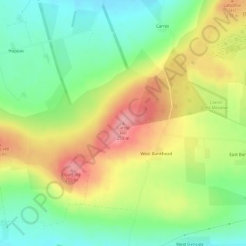
Name: Carrot Hill topographic map, elevation, terrain.
Location: Carrot Hill, Angus, Scotland, DD8 2JU, United Kingdom (56.55052 -2.88168 56.55062 -2.88158)
Average elevation: 192 m
Minimum elevation: 141 m
Maximum elevation: 256 m
Thank you for supporting this site ❤️
Make a donation
Make a donation
Other topographic maps
Click on a map to view its topography, its elevation and its terrain.
Thank you for supporting this site ❤️
Make a donation
Make a donation
Thank you for supporting this site ❤️
Make a donation
Make a donation
Thank you for supporting this site ❤️
Make a donation
Make a donation