
Thank you for supporting this site ❤️
Make a donation
Make a donation
Vignal topographic map
Click on the map to display elevation.
Thank you for supporting this site ❤️
Make a donation
Make a donation
About this map
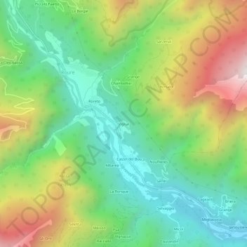
Name: Vignal topographic map, elevation, terrain.
Location: Vignal, Roure, Torino, Piemonte, Italia (44.97307 7.12222 45.01307 7.16222)
Average elevation: 1,170 m
Minimum elevation: 686 m
Maximum elevation: 1,990 m
Thank you for supporting this site ❤️
Make a donation
Make a donation
Other topographic maps
Click on a map to view its topography, its elevation and its terrain.