
Make a donation
Pignola topographic map
Click on the map to display elevation.
Make a donation
Pignola
Pignola is an Italian town in the province of Potenza in Basilicata. It borders to the east with Anzi, to the south-west with Abriola, to the west with Tito and to the north with Potenza. The Pignolese territory extends for 55.51 km2 and has an altitude ranging from 700 m of Pantano-Petrucco to 927 m of the inhabited center, up to 1476 m of Mount Serranetta which represents the highest point of the Pignolese territory. It has 6,962 inhabitants.
Make a donation
About this map
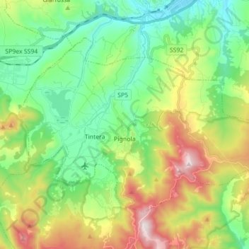
Name: Pignola topographic map, elevation, terrain.
Location: Pignola, Potenza, Basilicata, 85010, Italy (40.54255 15.72437 40.61478 15.86239)
Average elevation: 929 m
Minimum elevation: 655 m
Maximum elevation: 1,475 m
Make a donation
Other topographic maps
Click on a map to view its topography, its elevation and its terrain.