
Thank you for supporting this site ❤️
Make a donation
Make a donation
La Rabourdais topographic map
Click on the map to display elevation.
Thank you for supporting this site ❤️
Make a donation
Make a donation
About this map
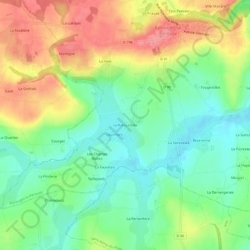
Name: La Rabourdais topographic map, elevation, terrain.
Average elevation: 57 m
Minimum elevation: 19 m
Maximum elevation: 110 m
Thank you for supporting this site ❤️
Make a donation
Make a donation
Other topographic maps
Click on a map to view its topography, its elevation and its terrain.
Étang de l'Anerie
France > Bretagne > Ille-et-Vilaine > Bazouges-la-Pérouse > L'Anerie
Average elevation: 64 m