
Thank you for supporting this site ❤️
Make a donation
Make a donation
Nsele topographic map
Click on the map to display elevation.
Thank you for supporting this site ❤️
Make a donation
Make a donation
About this map
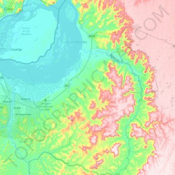
Name: Nsele topographic map, elevation, terrain.
Location: Nsele, Kinshasa, Democratic Republic of the Congo (-4.58908 15.34916 -4.11208 15.71545)
Average elevation: 431 m
Minimum elevation: 259 m
Maximum elevation: 725 m
Thank you for supporting this site ❤️
Make a donation
Make a donation
Other topographic maps
Click on a map to view its topography, its elevation and its terrain.