
Thank you for supporting this site ❤️
Make a donation
Make a donation
Maran topographic map
Click on the map to display elevation.
Thank you for supporting this site ❤️
Make a donation
Make a donation
About this map
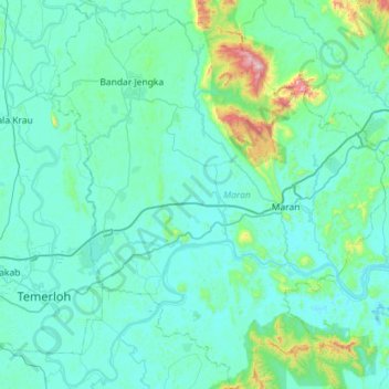
Name: Maran topographic map, elevation, terrain.
Location: Maran, Pahang, Malaysia (3.31436 102.42863 3.88585 102.92247)
Average elevation: 99 m
Minimum elevation: 5 m
Maximum elevation: 1,002 m
Thank you for supporting this site ❤️
Make a donation
Make a donation
Other topographic maps
Click on a map to view its topography, its elevation and its terrain.
Thank you for supporting this site ❤️
Make a donation
Make a donation
Thank you for supporting this site ❤️
Make a donation
Make a donation
Thank you for supporting this site ❤️
Make a donation
Make a donation
Thank you for supporting this site ❤️
Make a donation
Make a donation
Kampung Janda Baik
Before Janda Baik was founded in 1930, the area was primarily inhabited by Orang Asli tribes. The village was founded when some residents moved from Bentong to an area with a higher elevation due to the 1926 floods that affected Bentong and other low elevation areas. The earliest founders for this village are…
Average elevation: 501 m
Thank you for supporting this site ❤️
Make a donation
Make a donation
Thank you for supporting this site ❤️
Make a donation
Make a donation
Thank you for supporting this site ❤️
Make a donation
Make a donation