
Thank you for supporting this site ❤️
Make a donation
Make a donation
Frühmeßhof topographic map
Click on the map to display elevation.
Thank you for supporting this site ❤️
Make a donation
Make a donation
About this map
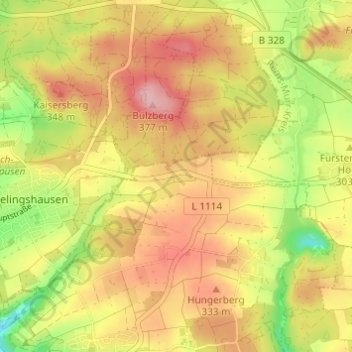
Name: Frühmeßhof topographic map, elevation, terrain.
Average elevation: 307 m
Minimum elevation: 224 m
Maximum elevation: 372 m
Thank you for supporting this site ❤️
Make a donation
Make a donation
Other topographic maps
Click on a map to view its topography, its elevation and its terrain.
71737
Deutschland > Baden-Württemberg > Rems-Murr-Kreis > Kirchberg an der Murr
Average elevation: 288 m